%2B-%2BThe%2Bmap%2Band%2Bthe%2Bflag%2Bof%2BState%2Bof%2BSouth%2BCarolina.jpg)
%2B-%2BThe%2Bmap%2Band%2Bthe%2Bflag%2Bof%2BState%2Bof%2BSouth%2BCarolina%2Bspate.jpg)
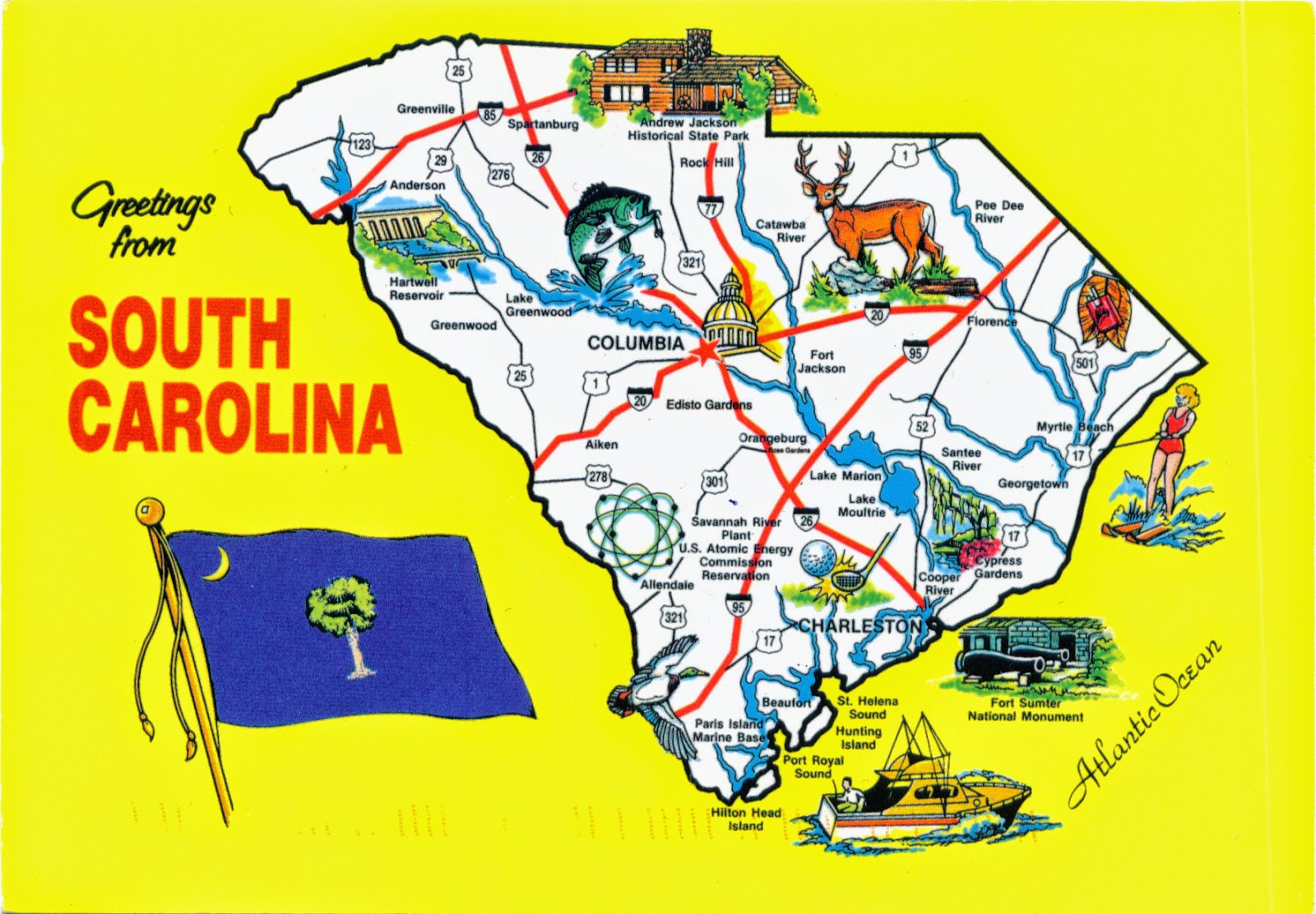
Located across the Savannah River, roughly triangular in shape and bordered to the north by North Carolina, to the south and west by Georgia, and to the east by the Atlantic Ocean, originally part of the Province of Carolina, South Carolina was the first of the 13 colonies that declared independence from the British Crown during the American Revolution, but also the first state to vote to secede from the Union, which it did on December 20, 1860. The largest city of the state is Columbia, chosen as the state capital in 1786. Vacationers are attracted to Myrtle Beach and the Grand Strand, to the Sea Island resorts, and to Charleston's stately homes and gardens. The state's historical places of interest include Fort Sumter National Monument, Kings Mountain National Military Park, and Cowpens National Battlefield.
The long, even coast lined with beautiful sand beaches on the Grand Strand north of Georgetown becomes generally marshy to the south and is sliced by a network of rivers and creeks, creating a maze of inlets and the famous Sea Islands. In this area are found cypress swamps, moss-hung oaks, beautiful flowering gardens, antebellum plantations, and the historic seaports of Georgetown, Beaufort, and Charleston, the latter a major tourist attraction and one of the chief ports of entry in the Southeast. The fall line on the state's Atlantic-bound rivers separates the coastal Low Country from the rolling Piedmont plateau of the Up Country and runs generally parallel to the coast. In the extreme northwest are the Blue Ridge Mountains, with Sassafras Mt. (1,085 m) the highest point. The Pee Dee, Santee, Edisto, and Savannah river systems drain the state, flowing from the highlands to the sea, creating rapids and waterfalls.
The first humans settled in the current South Carolina about 15,000 years ago. About 30 Native American Tribes lived there at the time the first Europeans arrived in the region. The first European who land here was the spaniard Francisco Gordillo in 1521, and five years later was founded San Miguel de Gualdape, the first European settlement in what is now United States. In 1629, King Charles I gave the regions that now constitute North Carolina, South Carolina, Georgia and Tennessee to Robert Heath, who named this colony Carolana ("Land of Charles" in Latin). The Province of South Carolina became a slave society after rice and indigo became established as commodity crops, and from 1708 the majority of the population were slaves. In 1776 the colony became the first republic in America. The American Revolution caused a shock to slavery, because 25,000 slaves (30% of those in South Carolina) fled, migrated or died during the disruption of the war.
On December 20, 1860, South Carolina became the first state to declare its secession from the Union. On April 12, 1861, Confederate batteries began shelling Fort Sumter in Charleston Harbor, and the American Civil War began. The state suffered many destructions, and nearly one-third of the white male population of fighting age died during the war. After the war, especially during the Populist and Agrarian movements of the 1890s, the state became a hotbed of racial and economic tensions. Early in the 20th century, it developed a thriving textile industry, attracted large military bases, and created tourism industries. Even if thousands of African Americans left the state for better opportunities in northern, midwestern and western cities, and by 1930 it had a white majority for the first time since 1708, the struggle of the African-American Civil Rights Movement took place here as well as other places in the South.
The flag of the state was based on one of the first Revolutionary War flags. Asked by the Revolutionary Council of Safety in the fall of 1775 to design a flag for the use of South Carolina troops, Col. William Moultrie chose a blue which matched the color of their uniforms and a crescent which reproduced the silver emblem worn on the front of their caps. The palmetto tree was added later to represent Moultrie's heroic defense of the palmetto-log fort on Sullivan's Island against the attack of the British fleet on June 28, 1776.
About the stamps

The first stamp is part of the series Winter Fun, which is based on nostalgic images of snowy childhoods. Art director Ethel Kessler designed the stamps using existing illustrations by Janet Atkinson, Jing Jing Tsong, and Christine Roy. With four playful designs, this series issued on October 23, 2014 celebrates some of the season’s most enjoyable activities:
• Ice-skating - It's on the postcard 1371
• Making snow angels - It's on other postcard 1359
• Building snowmen - It's on other postcard 1359
• Bird-watching - It's on other postcar1359
The art for the ice-skaters design was painted with acrylic on plywood with a dry brush technique to give the illustration a textured, folk-art feel. The other three were all hand-sketched and then digitally manipulated.


• Rudolph the Red-Nosed Reindeer- It's on the postcard 2299
• Santa Claus - It's on the postcard 1371
• The Abominable Snow Monster - It's on the postcard 2591
• The elf Hermey and Rudolph- It's on the postcard 2299

The last stamp is part of a set of four, depicting Gingerbread Houses and issued also for the Christmas, on November 6, 2013. The colorful gingerbread houses stand out against a bright blue background. Made with gingerbread and royal icing, each house has sugary fruit slices for shingles, peppermint sticks for support beams, and round, candy-coated chocolate for doorknobs and holly berries. Sally Andersen-Bruce photographed the houses, created by baker Teresa Layman.
• A house with a red door - it's on other postcard
• A house with a blue door - it's on other postcard
• A house with a green door - it's on the postcard
• A house with a orange door - it's on other postcard
This is a post for Sunday Stamps II-1, run by Violet Sky from See It On A Postcard. The theme of this week is Christmas - or the rarer Hanukkah - stamps. Click here to visit Violet’s blog and all the other participants.
References
South Carolina - Wikipedia
South Carolina Geography - Infoplease
Flag of South Carolina - Wikipedia
Sender: Denise
Sent from Greenvale (New York / United States), on 15.11.2014
Thank you for joining!
ReplyDeleteThose gingerbread houses are among my favourites.
And Rudolph is my favourite of the Christmas specials. It was on tv here last Sunday.
It's a nice collection! The winter fun stamps I especially like.
ReplyDeleteI am not familiar with the gingerbread house tradition, but the houses look great anyway. Thank you for sharing!
Enjoyed the Winter Fun.
ReplyDelete